Oct 06 Enhancing Public Transit Efficiency through Microtransit Planning and Optimization
Abhijeet Nawale
info@itcurves.net
Public transportation plays a crucial role in addressing urban mobility challenges and alleviating traffic congestion. However, in suburban and rural areas, there are additional challenges, such as covering larger areas with dispersed populations and limited fleet resources. Transit planners continually grapple with the task of balancing vehicle allocation, driver schedules, underserved areas, underutilized stops, low passenger miles, and excessive vacant miles. Therefore, the efficiency and effectiveness of public transit systems are pivotal factors in promoting sustainability across urban, suburban, and rural regions.
Recent technological advancements have ushered in innovative solutions aimed at enhancing the efficiency and accessibility of public transit systems.
This literature delves into the development and application of a cutting-edge microtransit planning tool, specifically designed to optimize transit routes and stops based on population distribution and passenger demand. As part of our research endeavors, IT Curves has created a Sandbox environment, which will be readily accessible to all our partnered transit planning agencies. This platform allows for a comprehensive analysis of current transit services and the review of suggested improvements within the plan.
Introduction
IT Curves sandbox has developed an emerging micro transit planning tool that offers a promising solution to improve transit service quality. This paper presents a comprehensive overview of a cutting-edge tool that combines transit route information and population distribution analysis to optimize transit networks.
Tool Functionality
2.1 Data Input
The microtransit planning tool operates independently, eliminating the need for interfacing with transit agency platforms. Users can simply input a city or transit agency name into the search bar. The tool validates the availability of General Transit Feed Specification (GTFS) data online and offers the option to upload a GTFS zip file if such data is not readily accessible.
2.2 Visualization
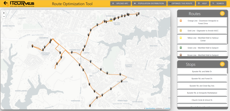
Upon successful input, the tool displays all the routes and stops of the selected transit agency in a right-side window. The first route is shown by default, and users can explore the entire network.
Population Distribution Analysis
3.1 Population Visualization
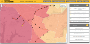
One prominent feature of the tool is its population distribution overlay, which superimposes population data onto the map. Areas with denser population concentrations are represented in darker shades, aiding in more informed strategic decision-making.

3.1 On-Demand Stops
Enabling the marking of stops on-demand empowers the optimizer to suggest additional flex-on-demand and deviated stops. The tool employs two methods to convert existing stops into flex-on-demand stops.
3.2 Passenger Count Data Upload
Not all densely populated areas consistently generate high subscription rates. This is why our planning tool is being designed to leverage actual passenger data for each stop. The tool intelligently analyzes and suggests which scheduled stops can potentially be converted to on-demand stops. This decision-making granularity is designed at the level of the day of the week and then the specific trip of the day.
3.3 Manually Changing Stops Status
Using population data, the tool allows users to designate less populated areas as ‘on-demand stops,’ where pickups require prior passenger notification. Users can select the percentage of on-demand service, with 0% allowing for an entirely on-demand route. This is in addition to considering historical ridership data per stop. The on-demand stops are highlighted in a distinctive red color.
Route Optimization
4.1 Algorithm Execution
The IT Curves route optimizer can be manually triggered after the selection of on-demand stops. The optimizer then suggests several new on-demand stops.” The optimizer ensures that trip duration remains unchanged when introducing new on-demand stops. It also suggests new stops along the current route path. The optimizer runs hundreds of iterations, utilizing a randomization function to determine if these new stops will increase ridership and enhance route efficiency.
4.2 Visualization of Results
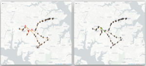
After the computation is complete, the screen displays two maps: the left map shows the actual route, while the right map displays the algorithm’s suggested route. Newly suggested stops are highlighted in green, offering a visual comparison between the original and optimized routes.
Statistical Insights
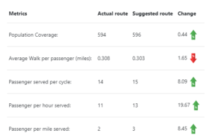
In the quest to optimize transit routes for enhanced efficiency, it is crucial to analyze the effects of these optimizations from multiple perspectives. The statistical insights provided by this microtransit planning tool provide a comprehensive overview of the potential benefits and outcomes. These essential metrics assist transit agencies in evaluating the effectiveness of route adjustments and making well-informed decisions:

Population Coverage:
Population Coverage represents the proportion of the population covered by the optimized route. This metric provides a crucial perspective on the accessibility and reach of the transit service. A higher population coverage indicates that a larger portion of the community will have access to public transit, promoting greater transit equity and potential ridership growth.
Average Walk per Passenger (miles):
Average Walk per Passenger measures the average distance, in miles, that passengers must walk to reach their nearest transit stop. Minimizing this distance is essential for enhancing passenger convenience and encouraging higher ridership. Reducing the average walk distance can lead to increased satisfaction and greater adoption of public transit as a practical mode of transportation.
Passengers Served per Cycle:
Passengers Served per Cycle quantifies the number of passengers accommodated during a single transit cycle. This metric highlights the efficiency of the transit service in terms of passengers throughout. Maximizing passengers served per cycle optimizes the utilization of transit resources and helps reduce operational costs.
Passengers per Hour Served:
Passengers per Hour Served measures the rate at which passengers are served by the transit route per hour of operation. This metric offers insights into the route’s capacity to handle passenger demand throughout the day, both during peak hours and off-peak times. Higher values indicate improved transit efficiency and responsiveness to varying passenger loads.
Passengers per Mile Served:
Passengers per Mile Served assesses the transit route’s efficiency by measuring passenger density along its length. This metric identifies areas with high passenger demand, aiding decisions on stop placement and route adjustments. Maximizing passengers per mile served optimizes infrastructure and resource utilization.
In conclusion, these statistical insights are invaluable tools for transit agencies and planners. They offer a holistic perspective on the benefits and trade-offs associated with route optimization. By carefully considering these metrics, transit professionals can make data-driven decisions to enhance public transit services, improve passenger experiences, and contribute to sustainable urban mobility solutions.
Conclusion
This literature paper underscores the capabilities and potential benefits of a state-of-the-art microtransit planning tool that seamlessly integrates population data. This tool empowers transit agencies to make data-driven decisions, optimizing routes and stops to enhance efficiency and passenger satisfaction. In the face of ongoing urban population growth, such tools are essential for advancing public transportation and promoting sustainable urban mobility.


